


Atlas Mountains Map: Major Peaks, Valleys, and National Parks
The Atlas Mountains are one of North Africa’s most impressive natural landmarks, stretching across Morocco, Algeria, and Tunisia. This vast mountain system separates the Mediterranean and Atlantic coastal regions from the Sahara Desert, creating a diverse landscape of rugged peaks, fertile valleys, and protected national parks.
Understanding an atlas mountains map helps travelers, hikers, researchers, and geography enthusiasts appreciate the region’s complex terrain and cultural significance.
Spanning more than 2,500 kilometers, the Atlas range consists of several distinct mountain chains. These include the High Atlas, Middle Atlas, Anti-Atlas, Saharan Atlas, and Tell Atlas. Each section has unique geographical features, ecosystems, and attractions that contribute to the region’s rich natural heritage.
Understanding the Atlas Mountain Range
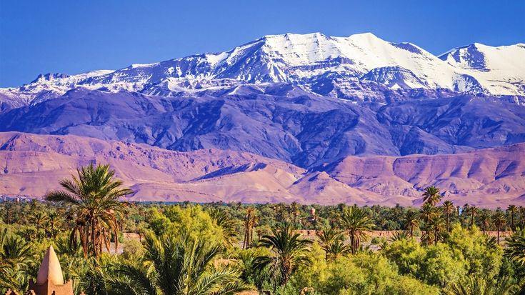
A detailed atlas mountains map reveals how the range stretches diagonally across North Africa. The mountains begin in southwestern Morocco and extend eastward through northern Algeria before reaching Tunisia. The system acts as a climatic barrier, influencing rainfall patterns and supporting diverse plant and animal life.
The High Atlas is the most famous section and contains the highest elevations in North Africa. The Middle Atlas is known for its forests and lakes, while the Anti-Atlas features ancient geological formations and arid landscapes. In Algeria and Tunisia, the Tell and Saharan Atlas ranges continue the mountain system, creating a mix of fertile highlands and semi-desert terrain.
Major Peaks of the Atlas Mountains
The Atlas Mountains are home to numerous notable peaks, attracting climbers and adventure seekers from around the world.
Mount Toubkal
Mount Toubkal is the highest peak in North Africa, rising to 4,167 meters above sea level. Located in Morocco’s High Atlas region, it is a popular destination for trekkers. The mountain offers breathtaking views of the surrounding valleys and distant desert landscapes. During winter, snow often covers the summit, creating a dramatic contrast with the arid regions below.
M’Goun
Standing at approximately 4,071 meters, M’Goun is the second-highest peak in Morocco. It forms part of the M’Goun Massif and is renowned for its scenic trekking routes. Visitors pass through traditional Berber villages and lush valleys while exploring this remarkable mountain.
Jebel Ayachi
Located in the eastern High Atlas, Jebel Ayachi reaches about 3,747 meters. It is less visited than Toubkal but offers equally stunning scenery. The mountain is known for its diverse wildlife and expansive views of Morocco’s interior landscapes.
Jebel Chélia
In Algeria, Jebel Chélia is the highest mountain, rising to approximately 2,328 meters. It dominates the Aurès Mountains and serves as an important landmark in northeastern Algeria. The surrounding region contains forests, cliffs, and unique ecosystems.
Fertile Valleys and Scenic Landscapes
The valleys of the Atlas Mountains are among the most beautiful and culturally significant areas in North Africa. These valleys support agriculture, provide water resources, and preserve centuries-old traditions.
Ourika Valley
Located near Marrakech, the Ourika Valley is one of Morocco’s most visited mountain destinations. The valley features rivers, waterfalls, and terraced farms. Traditional Berber communities continue to thrive here, offering visitors a glimpse into local culture and mountain life.
Dades Valley
The Dades Valley is famous for its dramatic rock formations and winding roads. Often called the “Valley of a Thousand Kasbahs,” it contains historic fortresses and fertile agricultural land. The valley serves as an important route through the High Atlas region.
Ziz Valley
The Ziz Valley stretches through eastern Morocco and is characterized by extensive palm groves and lush oases. Its green landscape contrasts sharply with the surrounding desert environment, making it a unique geographical feature.
Aït Bouguemez Valley
Known as the “Happy Valley,” Aït Bouguemez is a peaceful area surrounded by mountain peaks. The valley is popular among hikers due to its scenic trails, traditional villages, and welcoming atmosphere.
An atlas mountains map often highlights these valleys because they provide key access routes into the mountain range and showcase the region’s natural beauty.
National Parks of the Atlas Mountains
Several national parks protect the biodiversity and landscapes of the Atlas Mountains. These parks preserve endangered species, unique habitats, and important cultural sites.
Toubkal National Park
Established in 1942, Toubkal National Park surrounds Morocco’s highest mountain. The park covers a vast area of alpine terrain, valleys, and forests. Visitors can enjoy trekking, wildlife observation, and cultural experiences in nearby Berber villages.
The park is home to species such as Barbary sheep, golden eagles, and numerous endemic plants. Its rugged landscapes make it one of Morocco’s most important protected areas.
Ifrane National Park
Located in the Middle Atlas, Ifrane National Park is known for its cedar forests and cool climate. The park provides habitat for the endangered Barbary macaque, one of the few primate species native to North Africa.
Visitors often explore its forests, lakes, and hiking trails while enjoying the region’s distinctive natural environment.
Tazekka National Park
Situated near the city of Taza, Tazekka National Park protects diverse ecosystems that range from dense forests to limestone caves. The park offers opportunities for hiking, birdwatching, and geological exploration.
Its varied landscapes make it an important conservation area within Morocco’s mountain regions.
Chréa National Park
Located in Algeria’s Blida Atlas, Chréa National Park is one of the country’s oldest protected areas. The park contains cedar forests, mountainous terrain, and significant wildlife populations. During winter, some areas even receive snowfall, attracting visitors seeking outdoor recreation.
Geographic Importance of the Atlas Mountains
The Atlas Mountains play a crucial role in shaping North Africa’s environment. They capture moisture from Atlantic and Mediterranean weather systems, generating rainfall that supports agriculture and human settlements. Without these mountains, much of the surrounding region would be significantly drier.
The range also serves as a natural barrier that influences climate patterns and biodiversity distribution. Forests, rivers, and fertile valleys created by the mountain system support millions of people across Morocco, Algeria, and Tunisia.
For travelers, geographers, and outdoor enthusiasts, studying an atlas mountains map provides valuable insight into how these interconnected landscapes function. The map reveals the relationship between towering peaks, life-sustaining valleys, and protected natural areas.
Conclusion
The Atlas Mountains are far more than a collection of peaks. They form a vast and diverse geographical system that includes North Africa’s highest mountains, fertile valleys, and remarkable national parks. From Mount Toubkal and M’Goun to the Ourika and Dades Valleys, the region offers a wealth of natural and cultural attractions.
Whether exploring hiking routes, researching geography, or planning an adventure, understanding the layout of the Atlas range helps reveal the significance of this extraordinary landscape.
An atlas mountains map serves as an essential guide to discovering the peaks, valleys, and protected areas that make the Atlas Mountains one of the most fascinating regions in the world.
Categorii
Citeste mai mult
¿Cómo puedo hacer una reclamación en American Airlines? Viajar debería ser una experiencia tranquila, pero en ocasiones pueden surgir problemas inesperados. Muchos pasajeros se preguntan ¿Cómo puedo hacer una reclamación en American Airlines? cuando enfrentan retrasos, cancelaciones, inconvenientes con el equipaje o dificultades...

Goa is famous for its beaches, nightlife, and easy-going vibe. But ask anyone who has spent a few days here, and they will tell you the real magic happens after the sun goes down. That magic has a name: spa therapy. Whether you are a couple on your honeymoon, a group of friends on a trip, or a solo traveller who just wants to relax for an hour, Goa's spa culture has something for you. In this...

As energy prices continue to rise across Western Australia, more homeowners and businesses are investing in a solar system Perth WA Australia to reduce electricity bills and gain greater energy independence. Perth enjoys some of the highest levels of sunshine in the world, making it an ideal location for solar power generation. Installing a high-quality solar system can help you maximize the...

Mental health professionals today face growing demands to stay updated with clinical skills, ethical standards, trauma-informed care, and evidence-based treatment approaches. Whether you are a therapist, counselor, psychologist, or social worker, continuing education is essential for maintaining licensure and improving client outcomes. This is why many clinicians are now choosing bundled...

